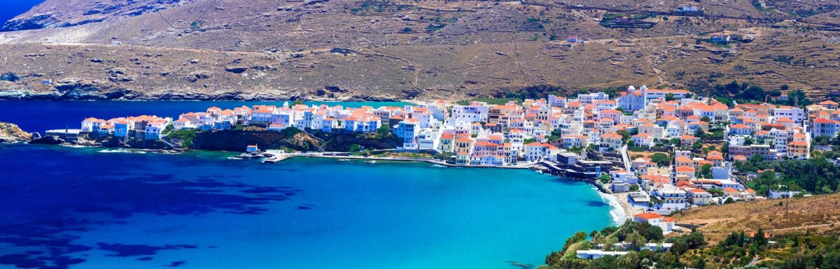
Nestled in the Cyclades archipelago, Andros Island offers the perfect escape for those seeking a holiday infused with picturesque landscapes, delightful beaches and cultural charm.
Just a mere two hours from Athens’ Rafina Port, Andros has gained worldwide recognition for its diverse attractions, ranging from scenic hiking trails to charming villages.
This guide aims to provide you with essential information to make the most of your visit to this stunning Greek jewel.
Boasting a diverse range of natural wonders, Andros entices its visitors with a blend of sophistication and rustic allure.
As the greenest and the second-largest island in the Cyclades, it promises an unforgettable experience for travellers seeking both relaxation and adventure.
With its cosmopolitan main town, beautiful traditional villages and postcard-perfect beaches, Andros has become an all-time favourite destination from Athens and should undoubtedly be on your travel bucket list.
During your stay in Andros, be prepared to embark on an exciting journey filled with memorable experiences.
From the bustling harbour town of Gavrio to the picturesque village of Batsi, Andros offers an extensive array of must-see attractions.
The island’s spectacular collection of beaches can cater to every taste, while avid hikers will relish the opportunity to explore some of the best hiking routes in Europe.
Whether you’re travelling solo or with your beloved ones, this guide to Andros is here to help you uncover the unforgettable charms of this enchanting Cycladic island.
Getting to Andros
Flights and Ferries
Andros, a beautiful island in Greece, is accessible only by ferry since it does not have an airport. There are 5 or 6 ferries departing daily from Rafina port in Athens to Andros island. The ferry crossing takes approximately 2 hours.
Andros is well-connected to other Greek islands as well, with a few weekly ferry routes to Mykonos, Syros, and Tinos. Make sure to check the schedules in advance to plan your journey accordingly.
Local Transportation
Once on the island, you’ll find various options for exploring its picturesque towns and beaches. Public buses are available and provide a budget-friendly means of transport. The bus routes cover most of the popular destinations on the island.
If you prefer more flexibility, consider renting a car or scooter. Numerous rental agencies are available on the island, and having your own vehicle allows you to explore at your own pace.
Lastly, taxis are available for those looking for a more convenient and private means of transportation within Andros. It’s essential to agree on the fare beforehand as it may vary depending on the time of day and distance.
Remember to be respectful of local customs and laws while using any transportation option. Enjoy your visit to charming Andros!
Best Time to Visit
Weather Considerations
The best time to visit Andros for ideal weather is between April 16th and July 1st, or September 17th and November 25th. Visiting during these periods allows you to enjoy pleasant average temperatures and less humidity. The summer months, particularly July and August, are the most popular time to visit due to the warm weather and beach activities, but be aware of the Meltemi winds, which are strong northern winds prevalent around the Cyclades islands during the summer.
In contrast, visiting before or after the peak summer period still affords you wonderful weather, while also benefiting from better prices and fewer crowds.
Festivals and Events
Andros has a rich cultural scene, hosting various festivals and events throughout the year. Some notable events include:
-
Korthi Festival: Taking place in July, this festival celebrates the island’s tradition of dancing, with performances and workshops on Andriot and other Greek dances.
-
Agia Marina: Held on July 17th in the village of Apikia, this religious celebration honours the patron saint of the island, featuring a litany, food, traditional music and dancing.
-
Pempti Pangia: This religious event occurs on August 15th, commemorating the Assumption of the Virgin Mary, with celebrations taking place across the island in several churches and villages.
Remember to check for updates on event dates and times before your visit, as they may be subject to change.
Top Attractions
Andros, a beautiful Greek island in the Cyclades, boasts a plethora of attractions for visitors to enjoy. From stunning beaches to ancient sites and cultural attractions, there’s something for everyone. In this section, we’ll explore the top draws of Andros – aiming to ensure your visit is a memorable one!
Beaches
Andros is home to a diverse range of beaches, each offering a unique experience. Some of the best include:
- Gavrio: A picturesque port with a lovely sandy beach, perfect for relaxing and enjoying the crystal-clear waters.
- Batsi: This charming village features a scenic sandy beach, ideal for families and watersports enthusiasts.
- Andros Town (Hora): Discover a quaint pebble beach near the main town, offering a serene escape just a short walk from the bustling centre.
With an array of stunning shorelines, there’s no shortage of places to unwind and soak up the Mediterranean sun.
Ancient Sites
Delve into the rich history of Andros by visiting some of its most remarkable ancient sites:
- Palaeopolis Archaeological Site: The island’s ancient capital offers fascinating ruins, including the remains of an ancient market, agora, and theatre.
- Tower of Agios Petros: This 12th-century tower stands tall on a hill overlooking the Aegean Sea, providing panoramic views and a glimpse into the island’s past.
By exploring these captivating sites, you’ll gain a deeper understanding and appreciation for the island’s heritage.
Cultural Attractions
Immerse yourself in the vibrant culture of Andros by visiting some of its renowned cultural attractions:
- Andros Archaeological Museum: Located in Andros Town, this museum hosts an extensive collection of artefacts from various eras in the island’s history.
- Museum of Contemporary Art: Also situated in Andros Town, this modern art museum showcases works from renowned Greek and international artists, playing a significant role in promoting contemporary art across the country.
Whether you’re a history buff or an art enthusiast, Andros offers unique cultural experiences that will enrich your visit.
Outdoor Activities
Hiking Trails
Andros offers a variety of hiking trails for outdoor enthusiasts to explore, leading through picturesque valleys, traditional villages, and ancient sites. Some popular trails include the Rainbow Blue Hole Trail, with its scenic bodies of water, and the Watermills Hiking Tour, taking you on a journey through history. The island is also known for its signposted hiking routes in the centre, providing a great opportunity for nature lovers to enjoy the beauty of the island.
Water Sports
For those seeking water-based activities, Andros is an excellent destination. With its strong summer winds, it’s popular for windsurfing, especially in Ormos Korthiou on the island’s eastern side. Additionally, the island offers RIB cruises, where you can enjoy snacks and drinks, and swimming tours to Zorkos beach. For a more leisurely experience, visit some of the best beaches in Andros, such as Vitali beach, where you can relax and soak up the sun.
Wildlife Watching
Andros is home to diverse flora and fauna, making wildlife watching an engaging and rewarding activity. While exploring the island’s lush landscapes, keep an eye out for rare and native species. Boat trips around the island also provide opportunities to spot marine life and birds in their natural habitats. For a more guided experience, consider joining a local tour to explore the island’s wildlife with an expert who can provide insights into the unique creatures that call Andros home.
Local Cuisine
Andros, a beautiful island in Greece, offers a delightful culinary experience for visitors to enjoy. The island’s gastronomy comprises traditional Greek ingredients and age-old recipes that reflect the rich local culture.
Traditional Dishes
In Andros, some common traditional dishes that you should try include:
- Lampriatis: A special dish reserved for the Easter season. This dish consists of lamb stuffed with three types of cheese, rice, eggs, parsley, and spearmint. It is then slowly baked in a wood oven for 8-10 hours.
- Amygdaloto: A simple almond pastry served during festivals, which is a true delight to the palate.
- Greek salad: A staple meal in Andros cuisine, the Greek salad consists of tomatoes, cucumbers, olives, red onions, and feta cheese.
- Mezedes: A popular assortment of snacks typically served alongside drinks such as ouzo.
- Souvlaki: A delicious kebab made from grilled meat, vegetables, and a variety of seasonings.
Popular Restaurants
During your visit to Andros, you may find a variety of restaurants to experience the delicious local cuisine. Here are a few you can consider:
- Karavostasis (Gavrio): Located at the south end of the waterfront, this restaurant offers a great dining experience, open for lunch and dinner daily during the summer season and on weekends from November to March.
- Local Spots: If you’re touring the island during the day, you’ll come across various local spots serving traditional Andros dishes. Be sure to give them a try for an authentic taste of the island’s cuisine.
Remember to indulge in the aromatic and tasty dishes while exploring the picturesque island of Andros. Happy eating!
Accommodation Options
Andros, a beautiful Greek island, offers a variety of accommodation options to suit the preferences and budgets of its visitors. In this section, we will discuss two main types of accommodations: Hotels and Resorts, and Villas and Vacation Rentals.
Hotels and Resorts
Andros boasts an array of hotels and resorts, providing visitors with various levels of comfort and luxury. Some of the popular options include:
- Krinos Suites Hotel: Located in the picturesque coastal village of Batsi, this 3-star hotel offers nine autonomous suites with sea views, combining aesthetics, comfort, and warm hospitality.
- Hotel Perrakis: This hotel features 44 rooms that provide sea-view balconies, and a pool terrace with spectacular views stretching from the mountains to the horizon. Higher suites overlook nearby Kypri Beach.
- Micra Anglia Boutique Hotel & Spa: Set within a restored 19th-century mansion in Chora, this 5-star boutique hotel offers accommodations ranging from standard rooms to a two-bedroom suite with a private pool.
Villas and Vacation Rentals
For travellers seeking a more private and home-like experience, Andros has numerous villas and vacation rentals to choose from. These accommodations provide a great option for families or groups who need larger living spaces and added amenities such as kitchens and private pools. Some popular choices include:
- Andros Holiday Villa: This 4-bedroom villa offers a fully-equipped kitchen, living and dining areas, and a private pool. Located in Chora, it provides easy access to the town’s attractions and amenities.
- Beachfront Villa Kypri: With stunning sea views and direct access to Kypri Beach, this spacious villa accommodates up to 10 guests, featuring an open-plan living area, fully-equipped kitchen, and a large outdoor terrace.
Andros Island has numerous other hotels, resorts, villas, and vacation rentals to explore, ensuring that visitors can find their perfect accommodation option for an unforgettable stay.
Tips for a Memorable Trip
Respecting Local Culture
Andros is a beautiful Greek island that cherishes its local customs and traditions. To have a memorable trip, it’s essential to show respect for the local culture. Some ways to do this are:
- Dress modestly when visiting religious sites such as churches and monasteries. Cover your shoulders and knees to show respect.
- Engage with the locals in a polite and friendly manner. Smile, say hello, and try to learn a few basic Greek phrases like “efcharisto” (thank you) and “kalimera” (good morning).
- Patronise local businesses and support the island’s economy. Buy from traditional shops, dine in local tavernas, and consider staying in family-owned hotels.
- Be mindful of noise levels, especially when staying in quiet villages or visiting cultural sites.
- Keep the environment clean by not littering – use bins provided and recycle when possible.
Safety and Health Tips
To ensure a safe and healthy trip to Andros, consider the following recommendations:
- Keep hydrated by drinking plenty of water, especially during the hot summer months.
- Wear sun protection, such as hats, sunglasses, and sunscreen with a high SPF to avoid sunburn.
- In case of any health issues, it’s always better to have travel insurance that covers medical expenses.
- Be cautious when swimming, especially in rough seas or at remote beaches. Pay attention to warning signs, and don’t swim alone if possible.
- Stay on marked hiking trails and avoid taking unnecessary risks while exploring the island’s beautiful landscapes.
- Keep an eye on your belongings, and don’t leave valuables unattended on the beach or in public spaces.
- Have the contact information of emergency services, such as the local police, fire brigade, and medical centres, in case of any emergency.
By respecting the local culture and following safety and health tips, you can have a memorable and enjoyable trip to Andros island.
Frequently Asked Questions
How do I reach Andros?
Andros, the northernmost island of the Cyclades group, is easily accessible from Athens. There are frequent ferry services from the ports of Rafina and Piraeus to Gavrio, the main port of Andros. The journey usually takes around 2 hours, depending on the ferry type you choose.
What are the top beaches?
Andros boasts several beautiful beaches, each offering a unique experience. Some of the best beaches on the island are:
- Batsi: A picturesque and lively beach with golden sand and clear waters
- Ahla: A peaceful, secluded beach with crystal-clear waters and lush surroundings
- Vitali and Vori: Both beaches are stunning and quiet, offering a perfect escape from the crowds
- Tis Grias to Pidima: A unique beach with an iconic rock formation
Best area to stay in Andros?
The best area to stay in Andros depends on your preferences and budget. Gavrio, the port town, offers a wide range of accommodations and is a good base to explore the island. Batsi is a more lively area, perfect for those seeking a vibrant atmosphere. Chora, the capital of Andros, provides a more traditional experience with its mixture of Venetian architecture and modern amenities.
How long should I visit?
The ideal duration for a visit to Andros depends on how much time you have and your interests. A day trip can give you a taste of the island, while a two-day trip allows time for beach hopping and visiting some key attractions. For a more immersive experience, consider spending three or more days to explore the island’s natural beauty and historic villages.
Andros vs Tinos comparison?
Andros and Tinos are both unique Cycladic islands with distinct characteristics. Andros is known for its lush landscapes, excellent beaches, and naval tradition, while Tinos is famous for its religious significance, picturesque villages, and marble craftsmanship. Both islands are great destinations, so your choice depends on your personal interests and preferences.
What are key attractions?
Andros offers a variety of attractions for visitors to enjoy, including:
- Blue Holes National Park: An extraordinary geological site with natural pools for swimming
- Andros Barrier Reef: A remarkable underwater ecosystem perfect for snorkeling and diving
- Chora: The island’s capital, showcasing a blend of Venetian and Cycladic architecture
- Forfar Field Station: An educational site focused on marine biology and conservation
- Hiking trails: Numerous trails, such as the Rainbow Blue Hole Trail, wind through the island’s stunning landscapes

Born and raised on the sun-drenched island of Crete, Sofia Mavromatis is a seasoned traveler and writer with a deep-rooted love for Greece’s vibrant culture, stunning landscapes, and rich history.